Magnitude 7.8 Earthquake Strikes Offshore Sarangani: At Least 18 Dead, Landslide Buries Homes in Glan
The Quake and Its Immediate Toll
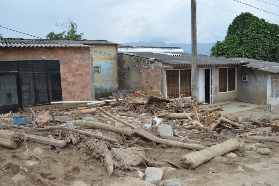
A magnitude 7.8 earthquake struck offshore Sarangani in the southern Philippines on June 8, 2026, at 07:37 AM Philippine Standard Time, killing at least 18 people and injuring more than 200 others. The bulk of the fatalities occurred in the municipality of Glan, where a landslide triggered by the tremor buried residential structures, according to AP News. The injury toll was reported separately by AP News on June 8, with conditions still developing as rescue operations continued.
The Philippine Institute of Volcanology and Seismology (PHIVOLCS) placed the hypocenter at coordinates 5.57°N, 124.98°E, at a shallow focal depth of 33 kilometers. That depth is significant: crustal earthquakes in the 30–40 km range concentrate seismic energy close to the surface, amplifying ground motion and slope destabilization relative to deeper events of equivalent magnitude. Sarangani province sits at the southeastern tip of Mindanao, a region that straddles multiple active fault systems feeding off the Philippine Trench and the Cotabato Basin tectonics to the northwest.
PHIVOLCS issued Tsunami Information bulletins in the immediate aftermath, consistent with protocol for any submarine or near-coastal event above Mw 7.0 in Philippine waters. The agency's tsunami monitoring infrastructure at tsunami.phivolcs.dost.gov.ph remained the live clearinghouse for wave-height observations and bulletin updates.
Tectonic Context: Why Sarangani Is Exposed
The southern Mindanao corridor is one of the most seismically active zones in the western Pacific arc system. The area near Sarangani sits proximate to the convergence of the Philippine Sea Plate and the Eurasian Plate, with the subduction geometry complicated by the Sangihe and Cotabato trenches nearby. This creates a dense network of both megathrust interfaces and secondary crustal faults capable of generating large, shallow ruptures independently of the primary plate boundary.
A focal depth of 33 km places this event within the upper crust, likely on an intraplate or slab-interface structure rather than deep within the subducting slab. Shallow ruptures of this type produce high peak ground accelerations over shorter epicentral distances and are particularly effective at triggering co-seismic mass movements — exactly the mechanism behind the Glan landslide. Southern Mindanao's terrain, characterized by steep coastal highlands receiving high annual rainfall, means slope saturation levels are often elevated even before seismic loading is applied.
Landslide Dynamics and the Glan Death Toll
The lethal landslide in Glan is consistent with a well-documented failure mode in Philippine earthquake events: co-seismic debris avalanches on slopes already at or near the angle of repose, accelerated by pore-pressure changes induced by strong shaking. The death toll of at least 18, with houses described as buried, indicates that the mass movement had sufficient volume and velocity to overwhelm structures rather than merely damage them.
We have seen this pattern before. The 1990 Luzon earthquake — a Mw 7.7 event — produced catastrophic landslides across the Cordillera, and the 2012 Compostela Valley earthquake cluster in Mindanao demonstrated that even moderate events on saturated slopes can produce disproportionate loss of life relative to structural damage from direct shaking alone. In Sarangani's case, the combination of a very strong mainshock, shallow depth, and proximity to highland terrain made slope failure a predictable secondary hazard from the outset.
Glan is a coastal municipality in the western part of Sarangani province, with settlement patterns that include barangays on elevated ground above the coastline — terrain that offers protection from storm surge and flooding but places residents in the path of hillside failures during seismic events.
Tsunami Protocols and Coastal Risk Management
PHIVOLCS's issuance of Tsunami Information bulletins reflects the agency's tiered warning architecture, which distinguishes between a full Tsunami Warning (requiring evacuation) and an Information bulletin (alerting coastal communities to monitor conditions). For an Mw 7.8 event at 33 km depth in a coastal offshore location, bulletin issuance was the procedurally correct response pending sea-level gauge confirmation of wave activity.
The Philippines operates within the Pacific Tsunami Warning System coordinated by the Intergovernmental Oceanographic Commission, and PHIVOLCS feeds real-time data to regional monitoring nodes. The offshore geometry of this event — epicenter situated seaward of Sarangani — meant the tsunami threat vector pointed primarily toward the Sarangani Bay coastline and potentially toward northern Sulawesi and the Celebes Sea littoral. Whether any measurable wave activity was recorded will be essential to the post-event technical review.
Response and Operational Picture
With at least 18 confirmed dead and more than 200 injured as of June 9, 2026, the operational picture in Sarangani province is one of active search-and-rescue overlapping with early damage assessment. Landslide rescue operations carry compounding risks: aftershock sequences following large shallow events can re-mobilize already unstable slopes, and the 33 km focal depth suggests the stress field in the surrounding crust has been substantially altered, elevating the probability of significant aftershocks in the hours and days following the mainshock.
The National Disaster Risk Reduction and Management Council (NDRRMC) would be the lead coordinating body for the government response, with regional civil defense offices in the SOCCSKSARGEN region (Region XII) and the Bangsamoro Autonomous Region in Muslim Mindanao (BARMM) providing localized command. International humanitarian capacity — including OCHA's regional office in Bangkok and the ASEAN Coordinating Centre for Humanitarian Assistance (AHA Centre) — typically activates monitoring posture for events of this magnitude in the Philippine archipelago, though formal external assistance requests depend on a government determination of need.
Looking at What This Means for Disaster Risk in Southern Mindanao
The broader pattern here is one that Philippine disaster managers have been grappling with for decades: the concentration of seismic risk in Mindanao, a region that simultaneously contends with conflict-related displacement, infrastructure deficits, and some of the country's highest poverty incidence rates. Sarangani province consistently ranks among the lower-income provinces nationally, which constrains housing quality, early warning dissemination reach, and post-disaster recovery capacity.
The Sendai Framework for Disaster Risk Reduction's emphasis on risk-informed land-use planning is directly relevant: communities situated on high-gradient slopes in active seismic zones require not just early warning systems but enforceable setback regulations and structural standards that account for co-seismic hazards beyond direct shaking. Whether the Glan landslide falls within mapped high-hazard zones under existing government geohazard surveys — conducted by the Mines and Geosciences Bureau — will be an important question for the post-event accountability review.
The death toll, still provisional as of June 9, may rise as rescue teams work through debris. The injury figure of more than 200 suggests a wider zone of structural damage extending well beyond the immediate landslide footprint, a signal that the mainshock's ground motion caused significant building damage across the affected municipalities even where slope failure did not occur.


