A Massive Earthquake Off the Philippines and the Warning System That Raced Against Time

What Happened
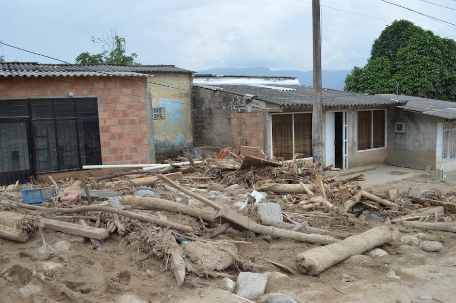
On June 8, 2026, a powerful earthquake measuring 8.2 in magnitude struck off the coast of Mindanao, the second-largest island in the southern Philippines. Within hours, tsunami warnings spread across the region — to Indonesia, Japan, and neighboring countries, according to Al Jazeera.
An 8.2 is not just bigger than an 8.0 — it's substantially more powerful. On the earthquake magnitude scale, each step up releases about 2.8 times more energy. At this strength, an earthquake can trigger tsunamis with waves several meters high in the open ocean, and even taller when they reach shore.
Why This Part of the Philippines Is So Seismic
The southern Philippines sits in one of the world's most geologically active zones. Two massive pieces of the Earth's crust — the Philippine Sea Plate and the Eurasian Plate — are constantly pushing against each other at a rate of roughly three inches per year. That slow collision builds up immense pressure beneath the ocean floor, and when that pressure releases suddenly, it triggers earthquakes.
Mindanao is particularly exposed. A deep trench off its eastern coast and the movement of those tectonic plates make it especially vulnerable to powerful seismic events. The Philippines' geological position means residents and authorities there live with this risk as a fact of life.
The Pattern of Recent Earthquakes
The Mindanao quake did not occur in isolation. A month earlier, in May 2026, a magnitude 6.0 earthquake hit the central Philippine island of Samar. Before that, in April, a magnitude 7.4 earthquake struck off Japan. Seismologists emphasize that these events do not predict each other in any reliable way — earthquakes don't follow a predictable sequence — but the clustering across early 2026 does signal a period of elevated seismic activity across the western Pacific region.
Why Warnings Reached Multiple Countries So Quickly
Indonesia and Japan received tsunami warnings not by accident but because of how waves travel and because of systems built after past disasters.
The Philippine Sea connects the region like a connected pathway. A tsunami from a distant earthquake can cross thousands of kilometers in just two or three hours, so countries farther away need to know what happened quickly. After the devastating 2004 Indian Ocean tsunami that killed over 200,000 people, countries in that region invested heavily in better warning systems and real-time communication. When an 8.2 earthquake occurs in the western Pacific, that knowledge now flows automatically to all potentially affected nations.
Japan experiences roughly 1,500 earthquakes per year — more than any other major nation. That constant seismic activity has forced Japan to build one of the world's most sophisticated early-warning networks. Those systems now benefit neighboring countries through shared data and instant alerts.
How the Warning System Works Against the Clock
Once an earthquake is detected, the warning clock starts. The Philippines Tsunami Warning Center, working with international partners like the Pacific Tsunami Warning Center in Hawaii and the Japan Meteorological Agency, issues alerts immediately if the earthquake is powerful enough and shallow enough to generate tsunamis.
For areas far from the epicenter — Indonesia, for instance — there may be one to three hours before waves arrive. That time is enough to evacuate people and secure ports. But for coastal communities near Mindanao, the situation is far more urgent. People living within 50 to 100 kilometers of the epicenter have only minutes, not hours. For them, the only real option is to move quickly to higher ground or to upper floors of sturdy buildings.
This creates a hard reality: no matter how good the warning system is, it only works if communities are already prepared and people can act fast. In many coastal areas of the Philippines where poorer residents live in low-lying informal settlements, that remains a serious challenge.
Broader Context
The 2011 tsunami in Japan is a sobering reminder. Despite having the world's most advanced warning systems, nearly 20,000 people died. The waves were taller than forecasters predicted, and not everyone evacuated even when warnings sounded. That disaster reset what the world expects from warning systems and what governments must do to prepare their populations — not just alert them, but actually get them to safety.
For the Philippines, the system activated on June 8 represents years of regional cooperation through agreements with Japan and the Pacific warning networks. The speed with which warnings cascaded across multiple countries shows that the institutional machinery built after the 2004 disaster is functioning. Whether it proved adequate on June 8 — whether evacuation actually happened, whether communities near the epicenter made it to safety — will be the true measure of preparedness.
What Happens Next
Once the tsunami threat passes, the focus shifts to damage assessment, search and rescue, and structural inspections. An 8.2 earthquake causes severe shaking that damages buildings on its own, separate from any tsunami damage.
Aftershocks are another concern. After a major earthquake like this one, scientists expect significant follow-up earthquakes — potentially in the 6 to 7 range — within hours or days. These can collapse already-damaged structures and occasionally trigger smaller tsunamis of their own. That cascading hazard complicates rescue operations and extends the period of danger.
The real learning happens afterward. National agencies and international tsunami experts will review what worked and what didn't — from the moment the earthquake was detected all the way through evacuation and response. Those reviews, more than the earthquake itself, shape how prepared the next generation of coastal residents will be.