A Strong Earthquake Strikes the Philippines—Here's What Happened and Why It Matters
A Strong Earthquake Strikes the Philippines—Here's What Happened and Why It Matters
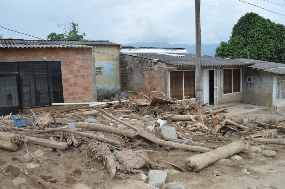
The Earthquake and What It Left Behind
On June 8, 2026, a powerful earthquake hit off the coast of Sarangani in the southern Philippines. It killed at least 18 people and injured more than 200 others. Most of the deaths happened in the municipality of Glan, where a sudden landslide — part of a hillside that broke loose — buried homes and the people inside them, according to AP News.
The earthquake measured 7.8 on the magnitude scale, which puts it in the category of major earthquakes. The Philippine Institute of Volcanology and Seismology (PHIVOLCS), the government agency that monitors earthquakes, said it struck 33 kilometers beneath the ocean floor. That matters because earthquakes closer to the surface shake the ground more violently in the area directly above them — like how a stone thrown into shallow water splashes more than one thrown into a deep pool. This violent shaking can destabilize hillsides and trigger landslides.
Why This Region Gets Hit So Hard by Earthquakes
Sarangani sits in one of the world's most earthquake-prone parts of the Pacific Ocean. The area lies where two giant pieces of the Earth's crust, called the Philippine Sea Plate and the Eurasian Plate, push against each other. This constant pressure creates cracks and weak spots in the rock where earthquakes happen regularly.
The shallow depth of this earthquake — 33 kilometers down — means it occurred in the upper layer of the Earth's crust, not deep underground. Shallow earthquakes send their energy straight up toward the surface in a way that shakes buildings and hillsides much more forcefully than deeper earthquakes of the same size would. The terrain around Sarangani makes this worse: steep hills and heavy rainfall mean the soil on many slopes is already wet and unstable. When the earthquake hits, it's like shaking a pile of wet sand that was already ready to slide.
The Deadly Landslide in Glan
The landslide in Glan followed a pattern that scientists have seen many times before in Philippine earthquakes. When the ground shakes hard, water trapped inside soil and rock creates pressure that weakens the slope. If the slope is already steep and wet, even that extra pressure is enough to make it collapse.
Glan is a coastal town with some neighborhoods built on elevated ground above the shore. That high ground offers protection from storm surge and flooding from the ocean, but it puts residents in danger when hillsides fail during earthquakes. The combination of a very strong mainshock, shallow depth, and proximity to highland terrain made slope failure a predictable secondary hazard.
The broader context here is that the Philippines has experienced destructive landslides from earthquakes before. In 1990, a magnitude 7.7 earthquake in Luzon triggered catastrophic landslides across the Cordillera region. More recently, the 2012 earthquakes near Compostela Valley in Mindanao showed that even moderate earthquakes on saturated slopes can kill more people than direct building damage alone would suggest.
How Officials Responded and Why Tsunami Warnings Mattered
PHIVOLCS issued what's called a Tsunami Information bulletin immediately after the earthquake. This is a standard step when an earthquake this size hits underwater or near the coast. The bulletin alerts coastal communities to watch for unusual ocean activity without necessarily ordering an immediate evacuation.
The Philippines works with a regional tsunami monitoring system coordinated by the Intergovernmental Oceanographic Commission. Because this earthquake's epicenter was offshore, the tsunami risk pointed primarily toward the Sarangani Bay coastline and potentially toward nearby regions. PHIVOLCS's tsunami monitoring system provides real-time updates on wave heights and conditions.
The Ongoing Emergency and What Comes Next
As rescue teams worked through the debris on June 9, the death toll remained provisional — it may have risen. The fact that more than 200 people were injured tells us that the earthquake caused serious building damage across a wide area, not just in the zone where the landslide occurred.
After a shallow, major earthquake like this one, the risk doesn't end when the shaking stops. Aftershocks — smaller earthquakes that follow the main event — often strike in the hours and days afterward. These aftershocks can re-trigger landslides on slopes that are already unstable, putting rescue workers at risk and burying more people in debris. The National Disaster Risk Reduction and Management Council would be coordinating the government's response across regions, with international humanitarian organizations standing by to offer help if requested.
The underlying challenge here is one that Philippine disaster managers have faced for years: Mindanao's southern regions sit in a very earthquake-prone zone, but many communities are also poor, have substandard housing, limited early warning systems, and weak recovery capacity. Sarangani province is consistently among the lower-income provinces in the Philippines, which means homes are often built to lower standards and people have fewer resources to rebuild after disaster.
Land-use planning matters more in places like this. Communities on steep slopes in earthquake zones need more than just warning systems — they need building codes that account for earthquake hazards, and they need rules that keep people from living in the most dangerous spots. Whether the area where the Glan landslide occurred was already flagged as high-risk by government geohazard surveys will be an important question for reviewing how the disaster unfolded.


