A Powerful Earthquake Strikes the Philippines—What Happened and What Happens Next

A Powerful Earthquake in a Danger Zone
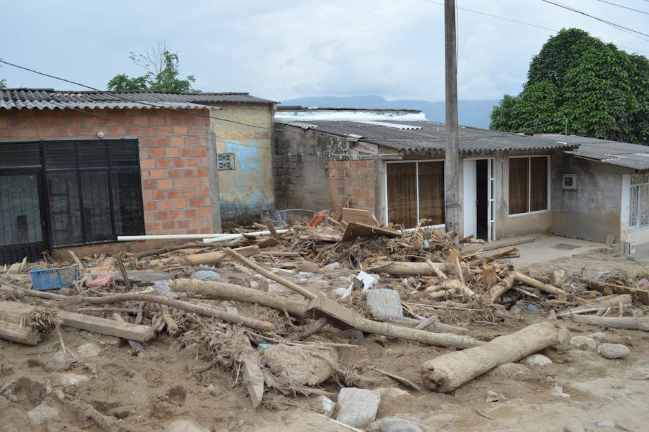
On the morning of June 7, 2026, at 7:37 a.m. local time, a major earthquake struck Mindanao, the second-largest island in the Philippines. The quake measured 7.8 in magnitude—strong enough to shake buildings hard and be felt for hundreds of miles. Within minutes, the Pacific Tsunami Warning Center issued an alert warning that ocean waves up to 10 feet tall might reach nearby coasts. People in low-lying areas began evacuating, and neighboring countries like Indonesia and island nations across the Pacific were also warned to take precautions.
AP News and the Philippine Institute of Volcanology and Seismology (PHIVOLCS) confirmed these details.
Why This Part of the World Gets So Many Earthquakes
The Philippines sits in one of the most geologically active regions on Earth. Think of the ground beneath the islands as a place where three giant jigsaw pieces—scientists call them "plates"—are constantly pushing against each other. One plate (the Philippine Sea Plate) is slowly sliding underneath the Philippine archipelago from the east at about 4 inches per year. Meanwhile, another plate (the Sunda Plate) presses from the west. This squeeze creates enormous pressure that builds up and occasionally releases violently as earthquakes.
Mindanao, where this quake happened, sits directly in the middle of this geological pressure cooker. The island is crisscrossed by major fault lines—cracks in the earth where plates collide—including the Philippine Fault Zone and the Mindanao Trench. A magnitude 7.8 quake is exactly the kind of powerful rupture these geological structures are built to produce.
To put this in historical context: the Philippines experienced a magnitude 7.2 earthquake in Bohol in 2013 and a destructive magnitude 7.9 in the Moro Gulf in 1976 that killed more than 5,000 people through both shaking and tsunami waves. These aren't flukes. The collision geometry of the plates here virtually guarantees that major earthquakes will keep happening.
What a Tsunami Warning Actually Means
When scientists warn of waves up to 10 feet, that's a serious threat. Waves that size can wash over coastal barriers, flood farming villages, and push debris and cars inland for several football fields. For emergency managers and coastal communities, a tsunami warning means one thing: get to high ground now.
The Philippines has a national early warning system run by PHIVOLCS, and the Pacific Tsunami Warning Center provides backup monitoring from Hawaii. This system is much stronger than it was two decades ago, in part because of lessons learned from the devastating 2004 Indian Ocean tsunami. Still, getting the warning to fishing boats already at sea and to remote island villages remains a stubborn challenge that authorities continue working to improve.
Which Communities Are Most at Risk
The people in immediate danger are those living on Mindanao's southern and southeastern coasts—cities like General Santos and Davao del Sur, plus smaller island communities scattered across the surrounding seas. These are mixed areas: some higher ground, but also flat coastal plains where fishing and farming employ many families.
Mindanao's southwestern region is also home to some of the Philippines' most vulnerable communities. The Bangsamoro Autonomous Region in Muslim Mindanao was created in 2019 as part of peace efforts after decades of conflict. It's still building up its disaster response capacity. When a major earthquake hits, those communities may not have all the resources they need for rescue and medical care as quickly as they need them.
The tsunami threat extends beyond the Philippines. Indonesia, Malaysia, and other Pacific nations could also see dangerous waves. Indonesian authorities were notified within minutes of the quake.
A Pattern That Will Repeat
The reason this matters extends beyond June 2026. The Philippines experiences about 20 earthquakes a day of various sizes, and suffers a damaging major quake—magnitude 6.5 or stronger—several times each decade. This is simply the geology of the place.
The Philippines has gotten better at earthquake preparedness in recent years. After damaging quakes in 2013 and 2019, the government strengthened building codes and evacuation systems. How well those improvements work in a real 7.8-magnitude event with a tsunami threat, tested in the early morning when people aren't expecting it, is a question officials were answering as this unfolded.
To what extent a disaster of this scale tests those systems, and whether regional or international assistance will be needed, depends on what officials learn over the following hours and days—how many people were hurt, how much infrastructure was damaged, and what the ocean actually does.
The Immediate Priorities Now
In the short term, scientists and emergency managers are watching three things: the exact depth where the earthquake ruptured, how long the earth shook, and what water levels tide gauges actually recorded on the coast. These details will tell them whether to escalate the tsunami warning, keep it as is, or lower it.
After magnitude 7.8 earthquakes, the earth typically continues shaking with strong aftershocks for weeks or months. Some of these can reach magnitude 6 or higher—strong enough to further damage buildings already weakened by the main quake.
The international humanitarian system was also starting to move. Organizations like ASEAN's Coordinating Centre for Humanitarian Assistance prepare to send help if needed. The Philippines traditionally manages its own response at first, but a quake this size with a tsunami could change that calculation depending on what the damage assessment shows.
PHIVOLCS and the National Disaster Risk Reduction and Management Council are the sources to follow as information becomes clearer. Casualty counts, damage reports, and the final word on tsunami risk will come over the next hours and days as officials gather data on the ground.