The Major Earthquake Off the Philippines: What Happened and Why the Warnings Spread So Fast

A Powerful Earthquake Shook the Southern Philippines
On June 8, 2026, an earthquake measuring magnitude 8.2 struck off the coast of Mindanao in the southern Philippines. The event immediately triggered tsunami warnings across the Philippines, Indonesia, and Japan, according to Al Jazeera. This region sits along one of Earth's most geologically active zones, where tectonic plates collide and grind against each other constantly.
To understand what an 8.2 magnitude earthquake means: the magnitude scale is logarithmic, which is a fancy way of saying that each step up in number doesn't just mean a little more energy — it means much more. An 8.2 releases roughly 2.8 times the energy of an 8.0. Earthquakes of this size can generate tsunamis with ocean waves reaching several meters high, and when those waves hit the shore, they can pile up even higher — sometimes exceeding 10 meters. The Philippine authorities were right to issue warnings immediately after detecting the earthquake, without waiting to see if waves actually formed. This approach became standard practice after the devastating 2004 Indian Ocean tsunami showed how precious those early minutes can be.
Why the Warnings Spread Across Three Countries
When a powerful earthquake happens underwater in the right way — at a shallow depth and with certain types of rock movement — the energy can send tsunami waves racing across the open ocean. These waves can travel thousands of kilometers in just two to three hours, which explains why Indonesia and Japan received warnings too.
Indonesia faces particular risk because its northern and eastern islands sit directly across from the Philippines. The country also upgraded its warning systems significantly after the 2004 Sumatra earthquake, so the infrastructure was ready to receive and relay alerts.
Japan's involvement shows how interconnected Pacific warning systems have become. Tokyo operates one of the world's most advanced earthquake and tsunami monitoring networks — this country experiences about 1,500 earthquakes per year, roughly 18% of all earthquakes on Earth. That constant activity created both a culture where people prepare for earthquakes and sophisticated warning systems. Now those systems benefit neighboring countries too, sharing real-time data that allows warnings to move quickly across borders.
Why the Southern Philippines Is So Seismically Active
The June 8 event did not happen in isolation. A magnitude 6.0 earthquake hit the island of Samar on May 4, 2026, and a month before that, on April 20, a magnitude 7.4 earthquake struck off Japan's Honshu coast. The clustering of these events in the first half of 2026 raises a natural question: are these tremors connected?
Seismology — the science of earthquakes — cannot reliably predict whether earthquakes in a region will trigger each other at this scale, so we cannot say one caused the others. But the pattern does underline that the first half of 2026 was a period of elevated seismic activity along the western edge of the Pacific Ocean.
The Philippines sits in one of Earth's most tectonically complex zones. The Philippine Sea Plate — a massive slab of the Earth's crust — is pushing underneath other plates at a rate of about 80–100 millimeters per year. That kinetic energy — the movement caused by these grinding plates — has to go somewhere, and it releases as earthquakes. Mindanao, the country's second-largest island, sits right in the middle of this active zone. Just offshore lies the Mindanao Trench, which plunges deeper than 10,000 meters, indicating just how intense the pressure is.
How the Warning System Works Against the Clock
Operators have only minutes in some cases. For communities within 50–100 kilometers of where the earthquake struck, tsunami waves could arrive before any warning message gets through. In those areas, the only real protection is what officials call "vertical evacuation" — moving to higher floors of sturdy buildings or running to higher ground — something people can only do if they have already practiced and know what to do.
The broader warning architecture that issued alerts across three countries that day represents decades of institutional learning, much of it born from tragedy. The 2011 Tōhoku earthquake in Japan killed nearly 20,000 people despite having Japan's state-of-the-art warning system in place. The waves were far bigger than forecasters had predicted, and some communities did not evacuate completely. That event reset international expectations for how high waves might go and how to communicate warnings in ways that actually change people's behavior.
The warning system that worked on June 8 relies on several layers: the Pacific Tsunami Warning Center in Hawaii serves as the authoritative source for threats across the Pacific; national agencies in the Philippines, Indonesia, and Japan feed that information to their coastal communities; and sensors called DART buoys (Deep-ocean Assessment and Reporting of Tsunamis) positioned across the Pacific send real-time data that lets forecasters distinguish a genuine tsunami threat from a smaller wave disturbance within the first minutes.
What Happens in the Hours After
The immediate sequence of actions follows a well-practiced playbook: evacuate people from low-lying coastal areas, close ports, halt maritime traffic, and monitor tide gauges and buoy data to refine estimates of how big the waves will be. Most of the time, authorities can tell within one or two complete wave cycles — usually a few hours — whether the threat is serious enough to justify the major disruption of an evacuation, or whether conditions are returning to normal.
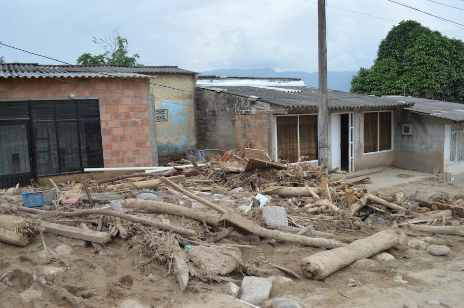
After the wave threat passes, the focus shifts to search-and-rescue operations in any areas that were hit, and assessing how much structural damage occurred from the shaking itself. An earthquake this size will damage buildings near the epicenter regardless of whether a tsunami followed. Additionally, an 8.2 earthquake typically spawns significant aftershocks — potentially in the magnitude 6–7 range — within hours or days, which complicates rescue work in already-damaged buildings and can occasionally trigger smaller, localized tsunamis.
The real measure of how well the system performed will come later. National agencies and the Pacific Tsunami Warning Center will conduct detailed reviews of how quickly information moved, whether warnings reached the people who needed them, and whether those people actually evacuated. Those reviews — more than the earthquake itself — are where the lessons that might save lives in the next major event are learned and written down.
For the Philippines in particular, a standing challenge remains: coastal poverty and informal settlements concentrate the most vulnerable people in exactly the places most at risk from tsunamis. Engineering and warning systems can only do so much if the underlying question of where people live and how prepared they are goes unaddressed.