The Philippines Earthquake: What Happened in Sarangani and Why It Matters
The Philippines Earthquake: What Happened in Sarangani and Why It Matters
The Earthquake and Its Immediate Impact
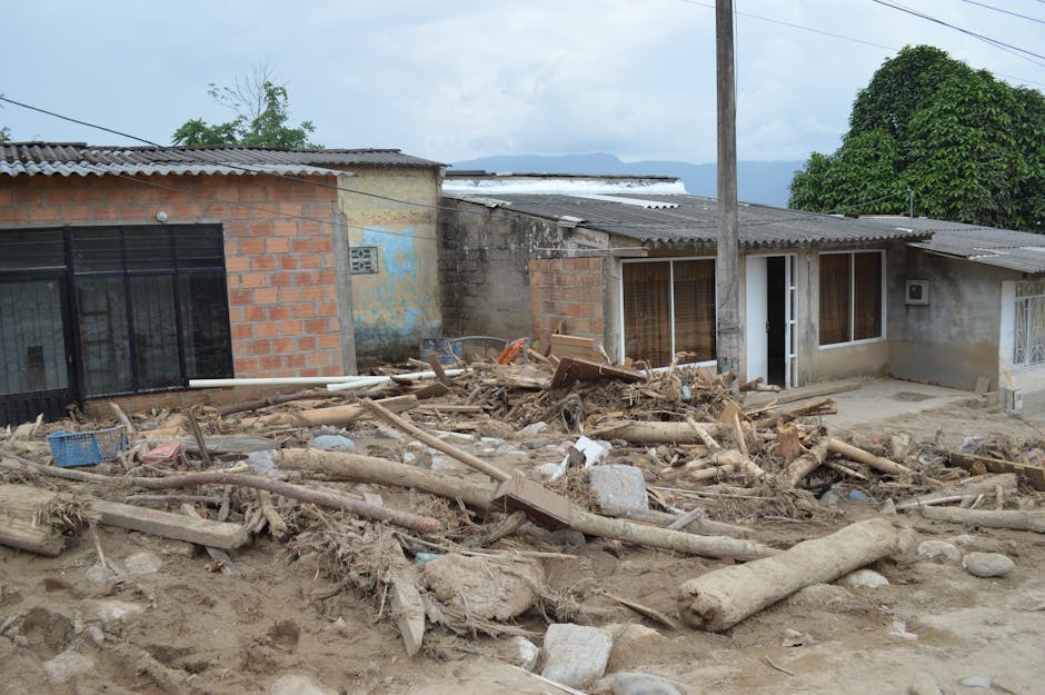
A magnitude 7.8 earthquake struck offshore from Sarangani province in the southern Philippines on June 8, 2026, at 7:37 AM local time, killing at least 18 people and injuring more than 200 others. Most of the deaths occurred in the municipality of Glan, where a landslide—earth and rock suddenly sliding down a hillside—buried homes and buildings, according to AP News. The injury count was reported separately by AP News on June 8, with rescue operations still underway as conditions continued to develop.
The Philippine Institute of Volcanology and Seismology (PHIVOLCS) pinpointed the earthquake's center at coordinates 5.57°N, 124.98°E, about 33 kilometers (roughly 20 miles) below the surface. That depth matters. Earthquakes in the 30–40 kilometer range release their energy close enough to the ground that shaking is more violent than deeper earthquakes of the same strength. This intense shaking is especially dangerous on steep hillsides, where it can shake soil and rock loose. Sarangani province sits at the far southeastern corner of Mindanao, an island where the Earth's crust is pulled and pushed by several major fault systems connected to deep ocean trenches nearby.
PHIVOLCS quickly issued Tsunami Information bulletins following standard protocol—any underwater earthquake larger than magnitude 7.0 near the Philippines gets this warning. The agency's tsunami monitoring system at tsunami.phivolcs.dost.gov.ph served as the official source for wave height readings and updates.
Why Sarangani Is in an Earthquake Zone
Southern Mindanao sits in one of the most seismically active regions of the Pacific. The area where this earthquake occurred lies where the Philippine Sea Plate (a massive slab of the Earth's crust in the ocean) is pushing under the Eurasian Plate (the larger continental slab beneath Asia and Europe). This collision is complicated by nearby deep ocean trenches, which create a network of fault lines—cracks in the Earth's crust where earthquakes happen. Some of these faults can rupture on their own, independent of the main plate boundary, and produce large shallow earthquakes.
A focal depth of 33 kilometers places this rupture in the shallow part of the crust, likely along one of these secondary faults rather than at the deepest collision zone. Shallow ruptures like this cause stronger ground shaking over shorter distances and are particularly good at triggering landslides. The southern Mindanao terrain adds to the danger: high coastal hills that catch a lot of rainfall mean the soil is often saturated with water before any earthquake strikes. Water-logged soil is looser and more prone to sliding when shaken hard.
How the Landslide Killed So Many
The deadly landslide in Glan follows a familiar pattern in Philippine earthquakes: intense shaking destabilizes slopes that are already on the edge of collapse, and groundwater trapped in the soil can suddenly shift during the quake, weakening the slope further. The death toll of at least 18 in a buried residential area shows the landslide had enough volume and speed to destroy structures rather than simply damage them.
This has happened before. The 1990 Luzon earthquake, a magnitude 7.7 event, set off catastrophic landslides across the Cordillera mountain range. In 2012, smaller earthquakes near Compostela Valley in Mindanao killed more people through landslides than through building collapse—a reminder that indirect hazards can be deadlier than direct shaking. In Sarangani's case, the combination of a very strong mainshock, a shallow depth, and steep highlands made slope failure likely right from the start.
Glan is a coastal municipality where many neighborhoods sit on elevated ground above the shoreline. Residents chose hilltop locations to stay safe from typhoon storm surge and flooding—a rational choice that unfortunately places them in the path of hillside failures during earthquakes.
Tsunami Warnings and Coastal Protection
PHIVOLCS's Tsunami Information bulletin reflects how the agency organizes its warnings: a full Tsunami Warning means evacuate now, while an Information bulletin means stay alert and monitor conditions. For a magnitude 7.8 earthquake at 33 kilometers depth located offshore, issuing an information bulletin was the correct procedure while waiting for actual sea-level measurements to confirm whether dangerous waves were forming.
The Philippines is part of the Pacific-wide tsunami warning system coordinated by international ocean monitoring agencies, with PHIVOLCS providing real-time data. Since this earthquake happened in the ocean north of Sarangani, the main tsunami risk pointed toward the nearby coastline and potentially toward Indonesia and the wider Celebes Sea region. Whether ocean gauges actually recorded measurable waves will be important for experts reviewing this event.
What Happens Now in the Affected Region
With at least 18 confirmed deaths and more than 200 injured as of June 9, 2026, rescue teams are searching through rubble while also assessing the full extent of damage. Rescue work after a landslide carries extra danger: aftershocks—smaller earthquakes that follow a main quake—can shake loose slopes that have already started to fail. A shallow earthquake at 33 kilometers depth like this one often triggers a sequence of strong aftershocks over the following hours and days, adding to the risk.
The National Disaster Risk Reduction and Management Council (NDRRMC) leads the government response, with regional offices in the affected areas taking charge of local operations. International humanitarian organizations in Bangkok and across Southeast Asia monitor situations like this, ready to help if the Philippine government asks for external assistance based on what they determine is needed.
The Bigger Picture: Disaster Risk in a Vulnerable Region
The real issue here is one Philippine disaster managers have confronted for decades: Mindanao sits squarely in an earthquake zone, but many of its communities also face other hardships—conflict-driven displacement, weak infrastructure, and poverty rates among the country's highest. Sarangani province ranks among the poorest in the Philippines, which means homes may be built to lower standards, early warnings may not reach everyone, and recovery after disasters takes longer.
International disaster experts emphasize something called risk-informed land-use planning: communities on steep slopes in earthquake zones need more than sirens and alarms. They need zoning rules that keep homes away from known danger zones, and building codes that account for earthquake-triggered hazards beyond just ground shaking. Whether Glan's buried neighborhoods fell in areas already identified as high-risk by the Philippine government's geological survey will be a key question as authorities investigate what happened.
The death toll remains preliminary as rescue work continues. The fact that more than 200 people were injured suggests the earthquake's ground shaking caused significant building damage across a wide area, not just in the immediate landslide zone. That wider pattern of damage is a signal that the mainshock was indeed very strong over the entire region.


