A Major Earthquake in the Philippines: What Happened and Why It Matters

A Major Earthquake Strikes the Southern Philippines
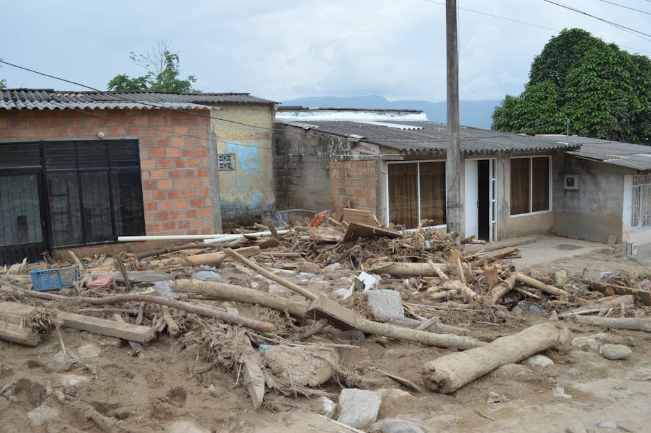
A magnitude 7.8 earthquake hit the southern Philippines on the morning of June 7, 2026, at 7:37 a.m. local time, shaking the island of Mindanao. The Pacific Tsunami Warning Center (PTWC) quickly issued a tsunami advisory, warning that waves as high as 3 meters (roughly 10 feet) could strike regional coastlines. This alert triggered evacuations across low-lying areas of Mindanao and potentially affected neighboring Indonesia, Palau, and other Pacific islands in the wave's path. AP News and the Philippine Institute of Volcanology and Seismology (PHIVOLCS) both confirmed these details.
Why the Philippines: Understanding the Tectonic Setting
The Philippines sits in one of the most earthquake-prone regions on Earth. Think of the archipelago as squeezed between two massive slabs of Earth's crust — the Philippine Sea Plate pushing in from the east (sliding beneath the underlying rock at about 10 centimeters per year) and the Sunda Plate pressing from the west. This crushing motion creates enormous stress that periodically snaps loose as earthquakes.
Mindanao is threaded by several major fracture zones — the Philippine Fault Zone, the Cotabato Trench system, and the Mindanao Trench — any of which can rupture and generate large earthquakes. A magnitude 7.8 sits in the upper range of what these structures can produce. This type of rupture, whether it occurs in the crust itself or where one plate slides under another, is exactly the kind that can efficiently push energy into the ocean and create tsunamis.
For historical context, a similar 2013 earthquake near Bohol (magnitude 7.2) and a larger 1976 event in the Moro Gulf (magnitude 7.9, which generated a devastating local tsunami that killed more than 5,000 people) occurred along the same tectonic structures. The southern Philippines isn't just occasionally seismic; the collision geometry virtually guarantees that major ruptures will happen periodically.
What a 3-Meter Tsunami Warning Means
For emergency planners and communities, a PTWC advisory warning of waves up to 3 meters is serious business. Waves in that range can wash over coastal barriers, flood low-lying farming and fishing villages, and carry enough force to move vehicles and debris inland several hundred meters. The PTWC uses different alert levels — Information Statements, Advisories, Watches, and Warnings — each signaling a different level of threat. A warning implies immediate danger and calls for evacuation of coastal zones.
The Philippines' National Disaster Risk Reduction and Management Council (NDRRMC) and local government units in affected regions would activate evacuation protocols under their disaster preparedness plans. PHIVOLCS runs a national tsunami early warning system, with the PTWC providing regional backup through international coordination. These systems are much better developed than they were two decades ago, though getting word to remote fishing villages and island communities in the Moro Gulf remains a challenge.
Who Faces the Greatest Risk
The communities most immediately at risk live along Mindanao's southern and southeastern coasts — places like General Santos City, Davao del Sur, the Sarangani coast, and scattered island municipalities in the Celebes Sea. These areas mix higher ground with extensive low-lying deltas and flatlands where fishing and agriculture concentrate both population and economic activity.
Mindanao's southwest region includes some of the Philippines' most economically and politically vulnerable communities. The Bangsamoro Autonomous Region in Muslim Mindanao (BARMM), established in 2019 after decades of conflict, is still strengthening its disaster response systems. This uneven capacity becomes critical when rapid search, rescue, and emergency medical care are needed.
The threat extends beyond the Philippines. A magnitude 7.8 earthquake in this part of the world can send tsunami energy across the Celebes Sea toward Malaysia's Sabah state and into the wider Pacific. Indonesia's meteorology agency (BMKG) would have received the same warning within minutes of the earthquake.
The Bigger Picture
This region has been shaped by previous catastrophes. The 2004 Indian Ocean tsunami — triggered by a magnitude 9.1 earthquake off Sumatra — forced the entire Indo-Pacific region to rethink disaster preparedness. The PTWC's current rapid-warning capability, the NDRRMC's protocols, and PHIVOLCS's monitoring network all exist partly because of lessons learned in 2004. But each major earthquake tests whether these systems actually work when the ground shakes at dawn, when fishermen are already at sea and markets are opening for the day.
The Philippines experiences roughly 20 earthquakes daily of varying sizes and suffers a major damaging quake — magnitude 6.5 and above — several times per decade. Disaster preparedness has genuinely improved since the 2013 Bohol and 2019 Cotabato earthquakes exposed gaps in building standards and evacuation infrastructure. Whether those improvements are enough for a magnitude 7.8 event is the question disaster managers are answering in real time as of June 8, 2026.
What Happens Now
In the hours and days ahead, several data points will matter. The exact depth where the earthquake ruptured, how long the rupture lasted, and the actual wave heights recorded at nearby tide gauges will tell officials whether the tsunami threat should be upgraded, kept as is, or downgraded. Magnitude 7.8 earthquakes typically trigger vigorous aftershock sequences, including some magnitude 6+ aftershocks that can damage buildings already weakened by the mainshock.
Internationally, organizations like the UN's humanitarian office (OCHA) and the ASEAN Coordinating Centre for Humanitarian Assistance are assessing whether to mobilize regional response teams. The Philippines typically prefers to handle crises through its own civil protection system initially, but an earthquake this size, combined with a tsunami threat, could change that calculation if casualties and damage prove extensive.
PHIVOLCS and the NDRRMC remain the primary sources for updates as the situation develops. Confirmed casualty figures, damage assessments, and whether tsunami warnings are lifted or escalated will emerge as officials gather information in the hours and days following the mainshock.