The 7.8 Mindanao Earthquake: How a Single Rupture Reshaped the Seabed

A 7.8-magnitude earthquake struck south of Mindanao on June 8, 2026, killing at least 61 people and collapsing buildings across General Santos City. In a geophysical consequence rarely seen unfold in real time, the seafloor along affected coastlines rose permanently by up to two metres.
The USGS located the epicentre 26 km southwest of Kablalan, in Sarangani province, and initially flagged significant damage as likely. Field assessments confirmed the impact was more severe than that forecast. The Straits Times and the Japan Times both reported on June 14 about the scale of coastal deformation, while the Manila Bulletin via PHIVOLCS confirmed coastal uplift and measurable shoreline retreat in post-event field surveys.
The Ground Moves — and Stays Moved
Coseismic uplift of this scale signals a thrust or oblique-thrust rupture on a shallow fault segment. Think of it this way: when two tectonic plates collide at an angle, one can suddenly override the other, forcing the seabed upward in a single violent motion.
The Philippine Mobile Belt is one of the most seismically active zones in the western Pacific, riddled with active faults where the Philippine Sea Plate and Eurasian Plate collide at roughly 8–10 cm per year. Sarangani sits near where the Cotabato Trench meets the southern Philippine Fault system — a geometry that accumulates both strike-slip (horizontal sliding) and compressional (squeezing) stress.
When such a fault ruptures, the overlying rock can thrust upward abruptly. A two-metre rise in seafloor elevation reshapes underwater topography, alters how sediment moves, and in shallow coastal zones, can expose reef flats or strand fish pens overnight. Shoreline retreat — where the coastline effectively moves seaward as land rises beneath it — is the surface expression of that same vertical displacement. PHIVOLCS documented both phenomena along the Sarangani coast, requiring updated nautical charts for the affected waters.
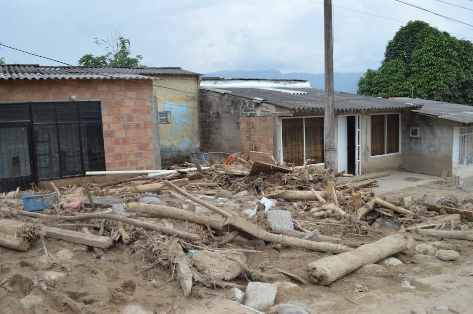
Human and Built-Environment Toll
General Santos City bore the heaviest structural damage, with multiple building collapses reported. The city's older masonry buildings, combined with the way alluvial soils fringing Sarangani Bay amplify ground motion, made structures there especially vulnerable. The confirmed death toll stood at 61 as of June 14 reporting; search and recovery operations in collapsed structures typically take days to weeks, so that figure may change.
The gap between the USGS preliminary assessment on June 7 and the fuller damage picture on June 14 reflects how disaster response unfolds in phases: seismic data arrives within minutes, casualty counts emerge over hours, and the complete picture of structural and geological damage emerges over the following week.
What Comes Next
The immediate concern is aftershocks. After magnitude 7.5+ earthquakes in the Philippine Mobile Belt, aftershock sequences can persist for months and occasionally produce magnitude 6+ shocks capable of destabilizing structures already weakened by the mainshock. Authorities and engineering teams are now racing against that window to assess and stabilize at-risk buildings.
The seafloor uplift also bears on tsunami risk. A two-metre vertical displacement of the seabed can generate a locally significant tsunami, depending on the exact rupture geometry and water depth. Whether that occurred on June 8, and at what heights, has not been confirmed in available records — but PHIVOLCS operates the Pacific warning network and would have issued advisories within minutes. The documented coastal uplift suggests the fault rupture extended to or near the seafloor, the configuration most likely to generate a tsunami.
Southern Mindanao has weathered large earthquakes before: destructive events in 1976 and 2019 shaped the current building codes and early warning systems now in place. The 2026 event will feed into the next revision of the national seismic hazard model and local building regulations for Sarangani — particularly for coastal development now sitting on newly elevated and potentially unstable ground.